This brief guide explains what visitors see at the reservoir called Lake Arenal and why it looks different from many U.S. lakes. Engineers built an earthen dam, diverted the Arenal River, and flooded a rainy valley so the basin would fill by 1979.
Before the project, small farms and rivers crossed the valley. The site worked well because heavy rains and nearby high ground made storage and hydroelectric energy efficient.
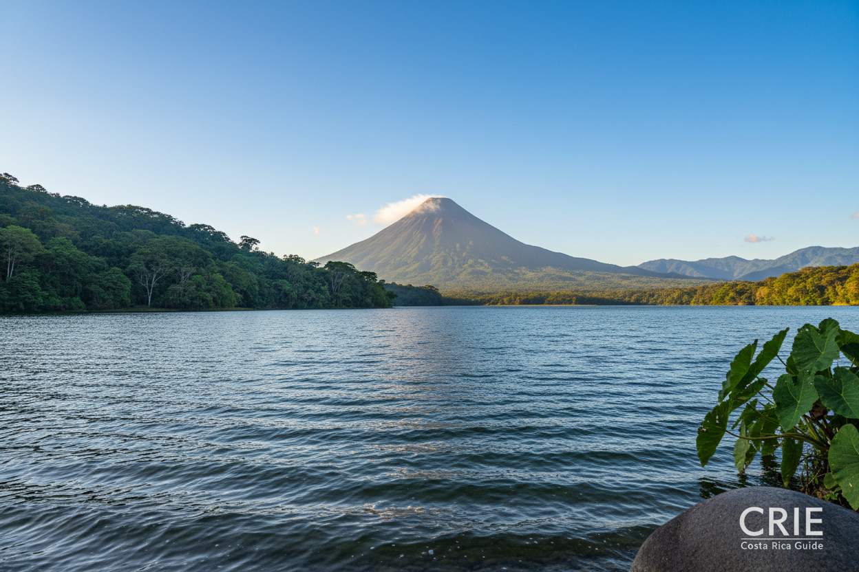
Today the lake hosts towns, marinas, and windy shorelines next to the volcano area. Readers will see varying reports of size because levels change with seasons and how wetlands are counted.
The rest of the article will cover what existed before the flood, what changed for locals, and practical tips for visitors. It will include do’s and don’ts, safety notes for roads and viewpoints, and a quick checklist and FAQ at the end.
Before the Reservoir: What Was in the Arenal Region Before Lake Arenal
Long before the large reservoir, a small natural lake and the Arenal River shaped daily life in this valley. The river ran through a gap between mountains and emptied the basin instead of filling it.

A small natural lake and the original river route
The original watercourse flowed like a ribbon across low land. Rain fed the lake and the river carried excess downhill toward Cañas. That simple route kept fields drainable and fertile.
Life in old Arenal and Tronadora
People lived on fincas, raised cattle, and made cheese. Old Arenal had a wooden school, a church, a Banco Nacional counter, and dances that marked social life. Tronadora kept its own rhythms and strong community identity.
Why the site mattered
Engineers chose this place because heavy rainfall, a wide flat basin, and a steady slope to Cañas meant stored water could become power. The nearby arenal volcano added rugged soils and scenic ridges around the land.
- Respect tip: if a local mentions “the old town,” listen and ask gently.
- Visitor note: broad slopes you pass now were once fields and neighborhoods.
| Feature (Before) | Characteristic | What you see today |
|---|---|---|
| Natural lake | Small, rain-fed basin | Became part of a larger lake area |
| River route | Flowed through mountain gap to drain valley | Rerouted for storage and power |
| Communities | Farms, wooden school, church, Banco Nacional | Towns moved or rebuilt on higher ground |
For a deeper look at the site’s history, see this detailed account.
History of the reservoir project
how-was-lake-arenal-costa-rica-made: The Project That Dammed a Valley
ICE chose the valley north of the arenal volcano because lots of rain, a bowl-like basin, and a steep drop toward Cañas made it ideal for storing water and producing power.
Why ICE picked this site
The mix of heavy rainfall and a flat basin meant a built reservoir could hold a lot without huge walls. A roughly 500-meter elevation drop to the river downstream made it efficient for energy production in costa rica.
The 560-meter diversion tunnel in plain English
Engineers bored a 560-meter tunnel to reroute the river temporarily. Think of it as a man-made shortcut so workers could build the dam in dry ground.

Building the earthen dam
Rather than solid concrete, crews stacked and compacted millions of cubic meters of sand, clay, and gravel. Over months, that built a huge engineered hill that holds back the water.
When the valley filled
Planning and relocation happened in the mid-1970s. As construction finished, water rose and by 1979 the valley had become a lake and modern reservoir.
Size and what numbers mean
Sources list the reservoir around 75 to 85 square kilometers. Seasonal changes and how shore wetlands are counted explain the different size reports.
What the turbines delivered
Falling water turned turbines, which made electricity and boosted national hydro capacity. The project added reliable energy for the country while changing the region’s landscape.
| Feature | What happened | Traveler take |
|---|---|---|
| Site choice | Flat basin + rain + drop in elevation | Scenic views, windy shores |
| Diverted river | 560 meters of tunnel | Built so dam could be finished dry |
| Dam type | Earthen (sand, clay, gravel) | Looks like a large engineered hill |
| Reservoir size | ~75–85 kilometers² reported | Area varies with seasons |
| Power | Turbines produced electricity | Major boost to national energy |
Do’s and don’ts near dam areas
- Do follow signs and use public viewpoints.
- Don’t cross barriers, gates, or “No Pasar” posts—treat them like U.S. power sites.
- Do keep distance from spillways and control buildings for safety.
Communities Moved and Remade: Nuevo Arenal, Tronadora, and the Human Story
Building the reservoir reshaped daily life: roughly 2,500 residents left farms and homes to start again on higher ground.
Staying in the original basin was not an option once plans advanced. Families chose between a land trade for a new house or accepting an assessed payout and moving away.
The main relocation sites are visible on modern maps. Nuevo Arenal was a planned rebuild near Santa María; construction began in 1975 after a community vote. Tronadora was rebuilt on higher ground across the new lake.

New towns brought clear upgrades: paved sidewalks, gutters, sewage, community centers, schools, churches, and first-time grid electricity and telephone service. Those gains changed daily life in practical ways.
Losses were real too. Families left fertile fincas, local routines, and a cemetery that flooded—a sensitive memory for many in the region and country.
Respectful visiting and small-town etiquette
- If a local mentions the old town, say: “I’ve read a little about the relocation—if you’d like to share, I’d listen,” and then follow their lead.
- Drive slowly near schools and parks, yield to pedestrians, and avoid blocking narrow driveways.
- Ask before photographing people, homes, horses, or farm areas and respect “Propiedad Privada” signs.
| Topic | What happened | Visitor note |
|---|---|---|
| Relocation | ~2,500 people moved | Recognize this is recent history for locals |
| New towns | Nuevo Arenal planned, Tronadora rebuilt | Both are compact, walkable towns |
| Infrastructure | Sidewalks, sewage, electricity | Improved services but emotional cost |
Lake Arenal Today: What Visitors Should Know Before They Go
On modern visits, the lake reads as both a recreational waterbody and a working energy site framed by green hills near the arenal volcano. It is Costa Rica’s largest lake and a top spot for fishing and windsurfing when the breezes kick in.
Expect scenic pullouts, service towns like Nuevo Arenal and low-key bases in Tronadora and Tilarán, and visible hydro infrastructure on the land. Roads around the shore can be narrow and curvy; use turnouts, drive slowly, and watch for sudden fog or rain.
Safety tips: dress in layers, secure loose gear, treat the water like a big open body, and avoid muddy edges after storms. Do use established access points; don’t cross fences or enter restricted hydro areas. See wildlife from a distance and never feed animals.
For residency questions, contact CRIE: WhatsApp +506 8706 3888 | info@crie.cr | www.crie.cr.
Quick checklist: wind layer, life jacket for water sports, charged phone, local operator for fishing or windsurfing, respect signs.
FAQ (short): Q: Is the lake safe for windsurfing? A: Yes, with an experienced operator and proper gear—winds change fast. Q: Is the dam open to visitors? A: Use public viewpoints only; do not enter secured areas.
FAQ
How was Lake Arenal created and when did the flooding occur?
What was in the Arenal region before the reservoir existed?
Why did ICE choose this site for a hydroelectric project?
How does a 560-meter diversion tunnel work in plain terms?
How is an earthen dam constructed?
How large is the reservoir today and why do size figures vary?
What role do the turbines play and how much electricity did the project add?
How many people were displaced and where did they go?
What gains and losses did relocation bring to affected communities?
How should visitors show respect when locals talk about the old towns?
What safety and etiquette tips apply in Nuevo Arenal and small lakeside towns?
Are dam and shoreline areas open to the public and what rules apply?
What recreational activities does the reservoir support today?
How deep is the lake and how does depth affect visitors?
How has the presence of Arenal Volcano influenced the reservoir area?
What should travelers know about transportation and distances around the lake?
Who manages the reservoir and where can one find official information?
Article by Glenn Tellier (Founder of CRIE and Grupo Gap)
Don't wait, contact us right now!
Call or WhatsApp Costa Rica +506 8373 2085 or +506 8706 3888
Call USA/Canada +1 305-906-6784